by Amanda Bertholf // Fall 2011

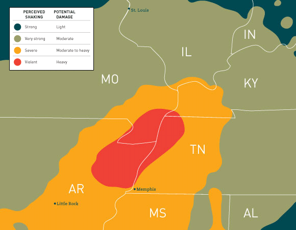
In the gray, early morning hours of Dec. 16, 1811, the sparse population in northeast Arkansas was rattled awake by a magnitude 7 earthquake. It was the first of three major earthquakes to strike the area. According to the U.S. Geological Survey, the ground rose, fell and cracked, trees snapped and uprooted, and landslides were abundant on the future site of Memphis, Tenn. Along the Mississippi River, large waves washed boats ashore and a sudden uplift beneath the river caused it to overflow its banks and briefly flow upstream.
The seismic activity lasted until February 1812 in an area that would become known as the New Madrid Seismic Zone (NMSZ). This area was named for the New Madrid, Mo., frontier-trading town that was severely damaged and evacuated during the 1811-12 events. The earthquakes, ranging in magnitude from 7 to 7.7, caused alarm from Detroit to New Orleans. Chimneys were knocked down as far as Cincinnati, about 350 miles from the epicenter. Homes were destroyed in St. Louis. “There was damage in Charleston, S.C., and it was felt as far away as Boston,” says Harold Sprague, BSCiE ’80, a seismic specialist engineer with Black & Veatch in Kansas City, Mo., and an adjunct engineering instructor in the Department of Civil and Mechanical Engineering at UMKC.
At about two o’clock, A.M., we were visited by a violent shock of an earthquake, accompanied by a very awful noise resembling loud but distant thunder, but more hoarse and vibrating, which was followed in a few minutes by the complete saturation of the atmosphere, with sulphurious vapor, causing total darkness. The screams of the affrighted inhabitants running to and fro, not knowing where to go, or what to do—the cries of the fowls and beasts of every species—the cracking of trees falling, and the roaring of the Mississippi … the current of which was retrograde for a few minutes, owing as is supposed, to an irruption in its bed … formed a scene truly horrible. In one person, a female, the alarm was so great that she fainted, and could not be recovered.
—Eliza Bryan
New Madrid, Territory of Missouri, 1811
Now, 200 years after the earthquakes hit the NMSZ, there’s renewed focus on studying the area. Researchers are investigating why there’s seismicity in the middle of the continent, why it’s still active and when an event will happen again—and a pattern is developing. “There’s a fault zone there that’s had earthquakes in the past, and it’s having earthquakes now,” says Tina Niemi, professor of geosciences in the College of Arts and Sciences at UMKC. Niemi, who studies paleoearthquakes, will be visiting the NMSZ this fall. “Researchers are now looking at the site of the 1811 rupture in Arkansas, and we’re finding evidence of earthquakes that are thousands of years old.”
The geological evidence of past earthquakes, such as features in the river valleys that show liquefaction (when saturated soil loses strength and stiffness) and sand blows (when sand moves up to the surface), is what leads researchers and scientists to believe an event like the one of 1811-12 will strike the region again. “We know that earthquakes repeat, but they don’t repeat on the same day or the same year,” says Randall Updike, B.S. ’66, regional geologist with the U.S. Geological Survey in Denver. “It’s in a range where sometimes they occur more frequently, other times more distantly.” So it’s not a matter of if the NMSZ will be hit again—it’s a matter of when.
